Alcántara de Júcar, officially Alcàntera de Xúquer in Valencian, is a small town in La Ribera Alta whose story brings together three distinctive threads: everyday heritage, the river landscape and collective memory. The Puríssima Concepció church, the traditional wash house and Les Penyetes recreational area provide named places with local context. A ceramic plaque dated 1982 adds an opportunity to discuss solidarity after the Tous flood carefully, without turning a real disaster into a superficial attraction.
The church and traditional wash house
The parish church of the Puríssima Concepció is the most visible monumental reference in the urban centre. Both the regional tourism portal and the provincial profile highlight it. Entry depends on worship and actual opening arrangements, but its exterior and surroundings provide a logical starting point. Rather than attributing undocumented artworks or architectural details to the building, this guide focuses on its role as a heritage and social landmark.
The historic public wash house preserves a different dimension of local life. Such places were connected with domestic labour, water supply and social interaction, so their significance extends beyond architecture. The regional source specifically identifies Alcàntera’s old wash house. Visitors can interpret its relationship with the street pattern and water system, while respecting any closure or sign and without assuming it remains an active facility.
A plaque and the memory of 20 October 1982
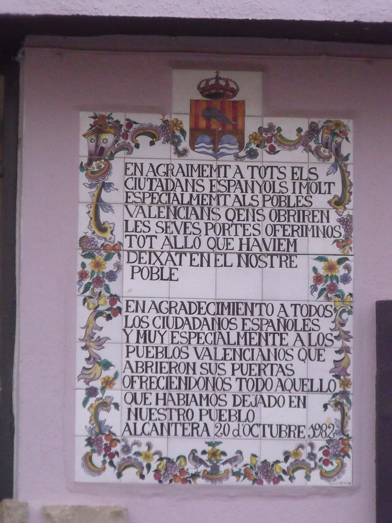
The main image is not a general town view. It shows a bilingual ceramic plaque thanking the citizens of Spain, especially Valencian communities, for opening their doors and offering help after the town had lost so much. Its inscription ends with “Alcàntera, 20 d’octubre 1982”. That date coincides with the failure of the Tous dam after severe rain, an event documented by the General and Photographic Archive of Valencia Provincial Council.
The provincial archive states that the Sellent and Júcar overflowed on that day, that La Ribera was hit particularly hard and that more than one hundred thousand people were affected. The shared date, wording and location allow the plaque to be interpreted in the context of solidarity surrounding the flood. This is a reasoned inference from the object and official archive, not a claim about who commissioned the plaque or the precise date it was installed; the consulted sources do not establish those details.
Reading the full inscription provides more value than using the plaque as decoration. It also calls for respect, because it refers to genuine loss and shelter offered between communities. Readers seeking deeper context can consult the Provincial Council’s documentary feature, which brings together photographs and administrative records of the disaster and the response.
Les Penyetes, the pine wood and the rivers
Les Penyetes is a shaded, tree-covered recreational area identified by Comunitat Valenciana Tourism. It can provide a rest or final stop after checking current access, maintenance and rules. It should not be confused with Pinar de Borja: València Turisme places the latter about two kilometres from the town and describes it as a wooded location. They are separate references, and the connection between them should not be advertised as a marked trail unless local information confirms one.
The municipality lies on the right bank of the Júcar, close to the Sellent, on relatively flat land beside Càrcer and below Serra Grossa. Riverside scenery, citrus groves and irrigation help explain its economy as well as its historic exposure to flooding. Rural tracks are working places: remain on permitted routes, do not enter cultivated plots and take particular care near river channels after rain.
A practical route without invented distances
- Begin around the Puríssima Concepció church and walk the surrounding streets to appreciate the compact scale of the settlement.
- Find the traditional wash house and consider its former purpose without expecting guaranteed interior access.
- Locate the thank-you plaque, read the complete inscription and then use the archive to understand the 1982 context.
- Finish at Les Penyetes if the area is open. Treat Pinar de Borja as a separate trip and verify local access before setting out.
The provincial tourism profile associates Alcàntera with rice cooked with beans and turnip, and with pumpkin-based arnadí. Both reflect the food culture of La Ribera, but daily availability depends on individual kitchens and the season. Ask before travelling instead of treating them as permanently available menu items.
Practical information and official sources
Alcàntera borders or lies very close to Càrcer, Beneixida, Gavarda and Cotes. This makes combined trips by vehicle possible, but does not turn the municipalities into a single walking route. Avoid the hottest hours in summer. During weather alerts, proximity to the rivers means following official advice and staying away from flood-prone areas.
- Comunitat Valenciana Tourism: Alcàntera de Xúquer
- València Turisme: heritage, landscape and food
- Valencia Provincial Council archive: the Tous flood
Independent onward ideas include Alberic, Algemesí and Alfarb, or the complete municipality guide finder.
The editing date records changes to the text, not a new check of opening hours, telephone numbers or accessibility. Specific verification dates, where recorded, appear beside the relevant information.